Backpacking in the Pictured Rocks National Lakeshore

Last weekend Alex and I took a quick trip to the UP to backpack along the Pictured Rocks National Lakeshore. We visited the UP last summer and weren't really sure what to expect on that trip. I hadn't researched any hikes so we just drove around until we found one that looked interesting. We happened upon one that took us along a mile hike into the woods before bringing us on the shores of the prettiest beach I have ever seen in the Midwest. It was the first time I had seen Lake Superior and I was floored by the crystal clear and calm blue water. We spent the afternoon relaxing in the cool sand of what felt like our own private beach before we headed back to the parking lot where we ran into backpackers making their way down to the shore. I had never been backpacking before but I remember thinking how cool it would be to set up camp in the backcountry, especially within earshot of gentle lulling waves. A year later we returned to do just that!
Activity: Backpacking from Chapel Parking to Beaver Creek Backcountry Site
Date Visited: 6/11/16 - 6/12/16
Distance: 21.4 miles
Trailhead: Chapel Basin Parking Lot

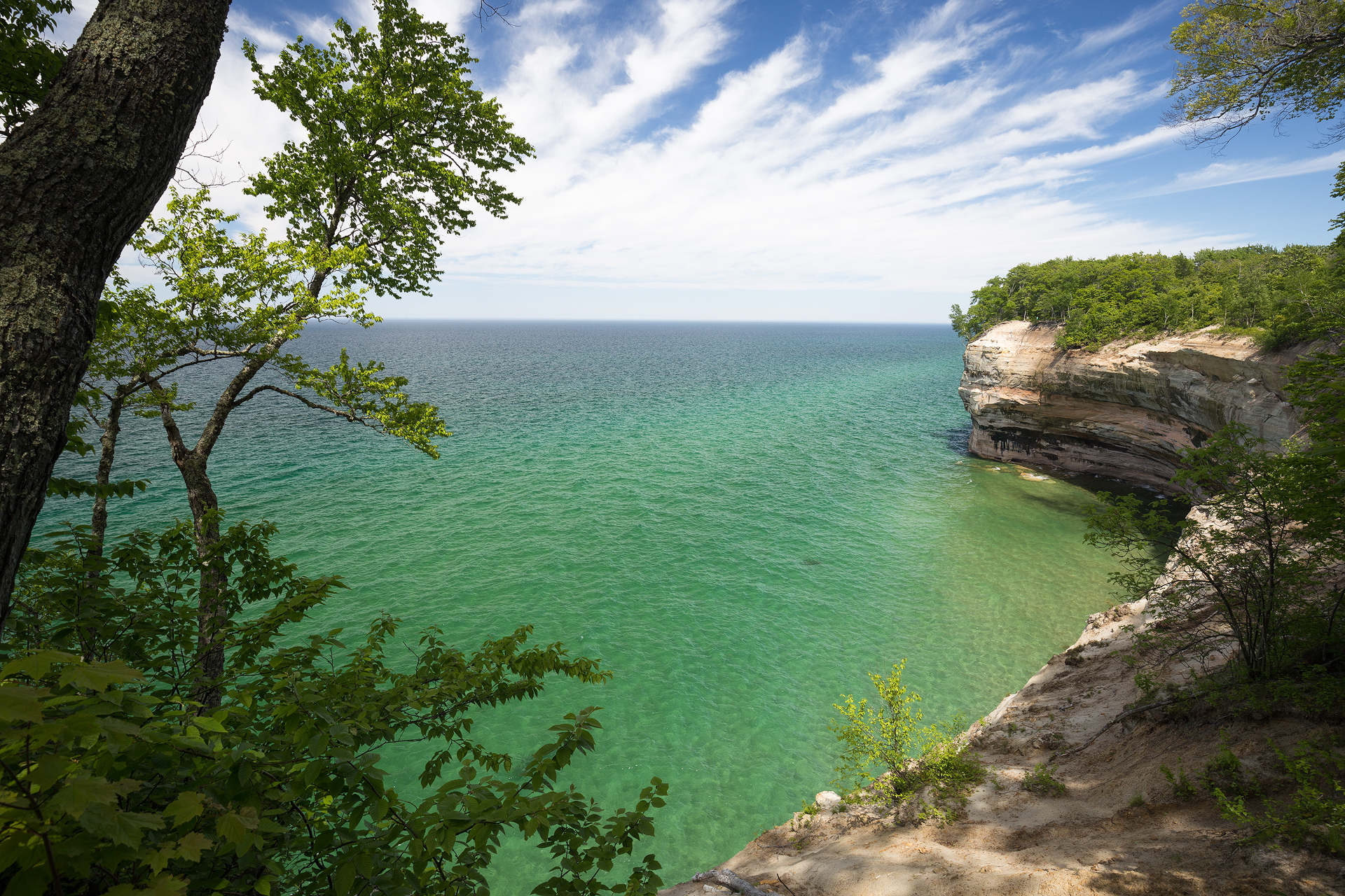
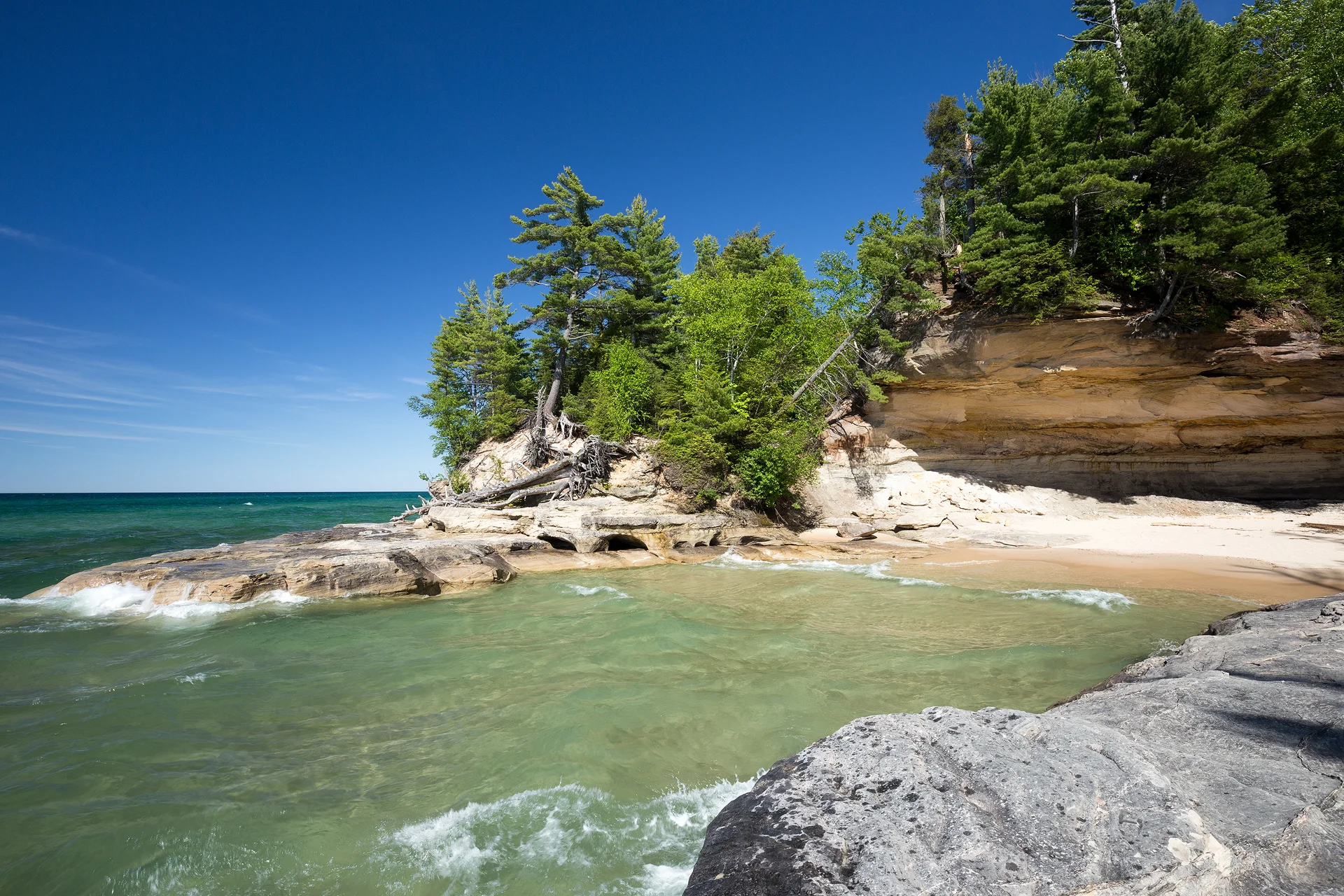
Pictured Rocks National Lakeshore spans 42 miles of Lake Superior and is comprised of 50' to 200' sandstone cliffs. The lakeshore gets its name from the colorful striations and patterns on the rocks. It stretches from Munising, MI to Grand Marais, MI and the entire length is full of scenic rock formations, sea arches, waterfalls, rivers, and the pristine waters of Lake Superior.
After researching hikes in Pictured Rocks, I decided to hike the famous Chapel Loop with an extension to Beaver Creek to see Spray Falls and a few other scenic beaches along the way. The entire hike was 21.4 miles. We hiked 8.8 miles the first day and 12.6 the second day but this hike could easily be stretched into 3 days/2 nights if you have the time and want shorter hiking days. The long days were a nice challenge to see if we could complete that sort of mileage with our fully loaded packs. Turns out we could, but walking wasn't much of an option the day after...
Day 1 - Chapel Basin Parking Lot to Chapel Beach to Beaver Creek Backcountry Site
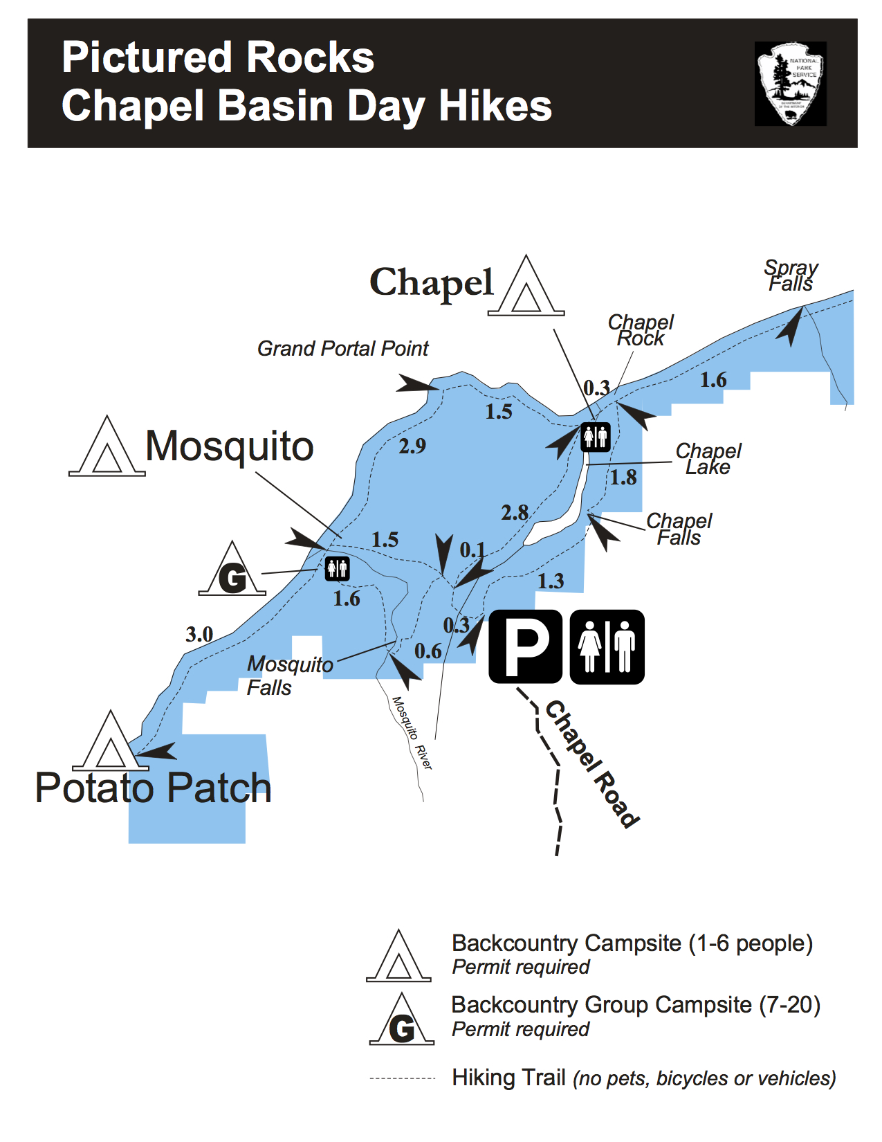
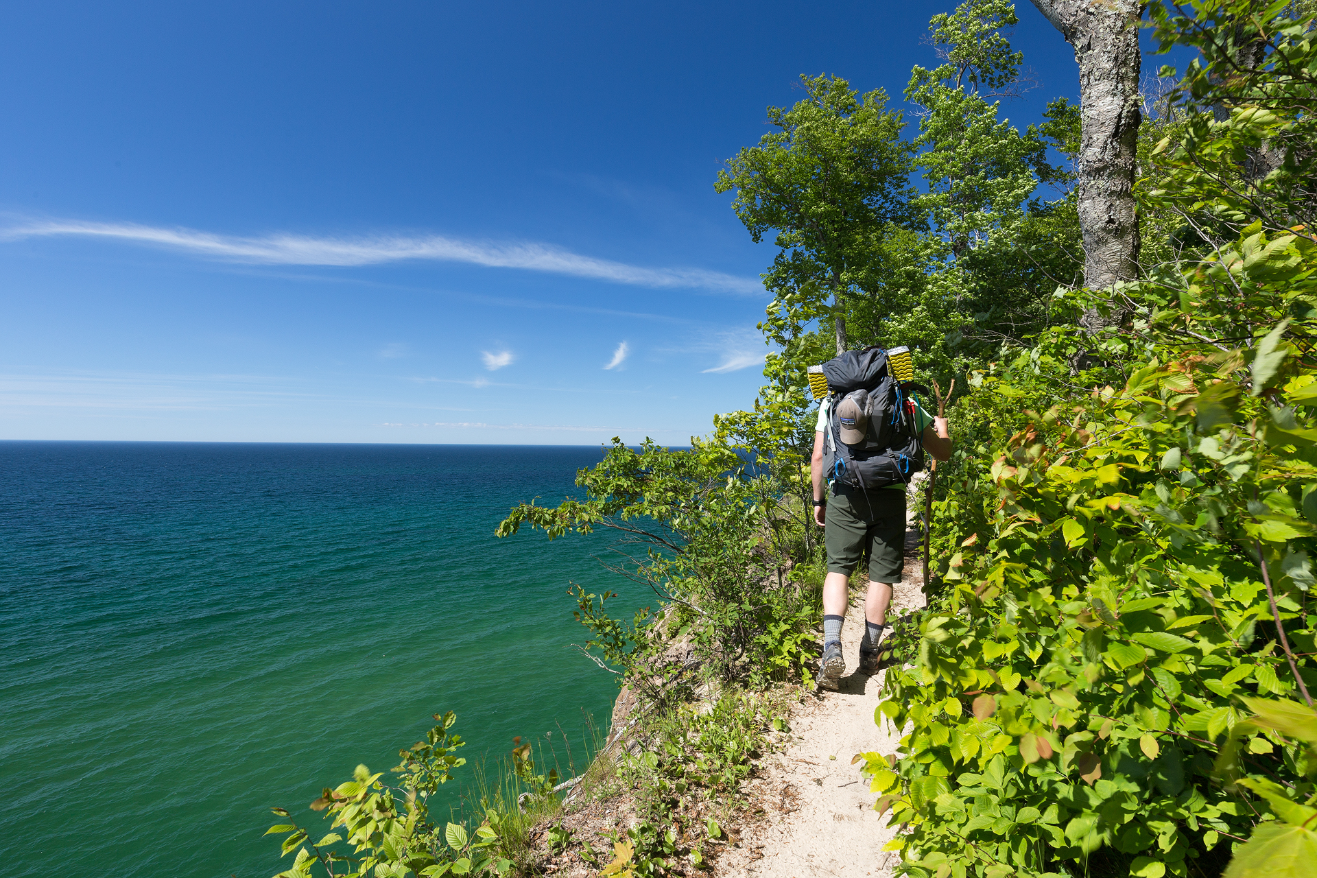
We headed out from the Chapel Basin Parking Lot at around 12:30pm. From the trailhead we veered left. The hike started at a level grade through a beautiful forest, sunbeams piercing the canopy and lighting the forest floor. After 0.3 miles we reached a 3-way intersection and followed the sign that pointed right, towards Chapel Beach. For another 2.9 miles we followed the trail through the woodland until the trees finally broke and we found ourselves on the shore of Chapel Beach. It was the perfect spot for a snack and water break. I took off my shoes and waded through the frigid waters. The turquoise hue may give the water of Lake Superior a tropical feeling but don't be fooled, the water was ice cold.

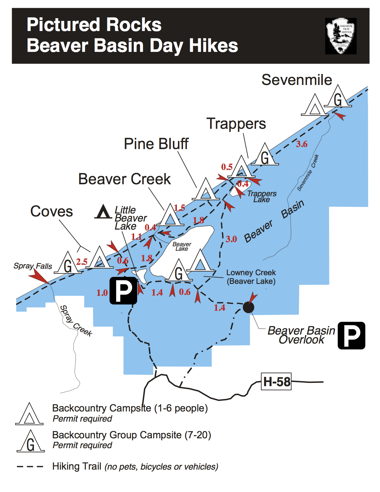
After our break at Chapel Beach we continued east on the trail. A sign indicated the Beaver Creek backcountry site, our final destination for the evening, was 5.6 miles away. With the sun not setting until 9:45pm we had plenty of time to make it to our campsite before dark. From Chapel Beach the trail meandered through the forest with plenty of breaks in the trees that allowed us to appreciate the stunning shoreline.


1.6 scenic miles later the trail passes Spray Creek and Spray Falls, a stunning 70' cascade pouring off the sandstone cliffs into Lake Superior. A quarter mile east of the waterfall is an outcrop that gives an unobscured view of the waterfall. It is the first waterfall of its kind I have ever seen. I've seen waterfalls pouring over cliffs and culminating in ponds that run into a river but I have never seen a waterfall pouring over a cliff into a large body of water like this before. This was another perfect spot for a water break.

From Spray Falls it is another 4 miles to Beaver Creek. The trail is easy to follow and relatively flat with gradual inclines and declines and a few steep sections that are made easier by stairs the park service installed. A recent rain made the trail extremely muddy. A few sections were like small swamps. Thankfully my Lowas are completely waterproof! As we followed the trail we were graced with more beautiful views of the lakeshore. Each view was similar to the last but also unique so we stopped at each one.
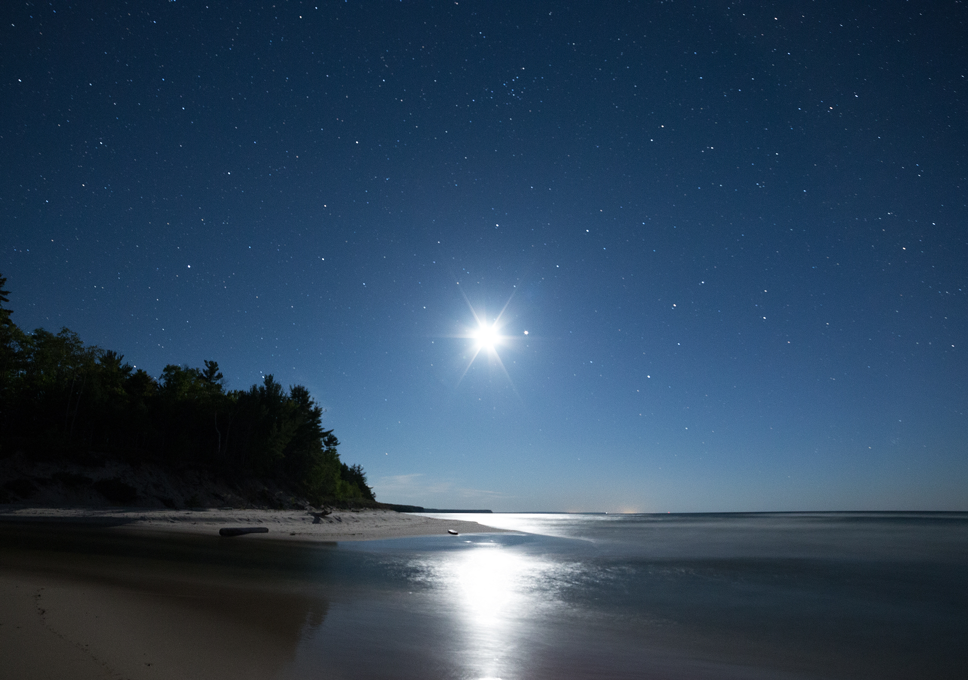
At around 6pm we made it to the Beaver Creek backcountry site. There was already a handful of campers set up so we didn't waste any time finding a spot of our own. Setting down my pack for the evening was a relief. It felt like I was floating when I walked around without it on. We quickly pitched the tent and headed down to the beach near the backcountry site to eat dinner. It was cold and windy so after we ate we didn't linger and soon retired to the tent for a nap. The sunset wasn't until later so we had a good amount of time to relax. I drifted in and out of sleep until our 9pm alarm indicted it was time to get up! We opened the tent door to find that we had positioned the tent to perfectly align with the setting sun. I debated whether I should go down to the shores to watch the sunset or just watch it from our tent! After snapping a few pictures of the sun flare through the tent we headed down to the beach. Despite having the beach and its perfect, unobstructed view of the setting sun over Lake Superior only steps away from the backcountry sites, there were surprisingly no other campers who joined us for sunset!

After sunset we headed back to the tent for yet another nap before doing some night photography around midnight. The community fire pit at Beaver Creek was roaring and a few campers were situated around it, exchanging stories. Alex and I headed down to the beach and set up our tripods. The moon was a half crescent and provided us with enough light to illuminate the beach. We didn't stay long; the 5+ hour drive and the 8 hour hike really wore us down so we didn't have much energy and headed back to the tent after a few minutes.
Day 2 - Beaver Creek Backcountry Site to Chapel Beach to Mosquito Beach to Chapel Basin Parking Lot
We woke up early the next morning as we had a 12+ mile hike planned for day 2 and still had to drive back home. We set the alarm for 6:30am and were packed up within minutes. Not a single other campsite was stirring yet so we were graced with an empty trail for the first 5 miles. We started at a fast pace, clocking the first 1.5 miles in just over 25 minutes. The first 5 miles we were just retracing our steps from the previous day so we were eager to get that portion behind us and onto the new section of the trail. We made it back to Chapel Beach in about 2 hours and as we were passing Chapel Rock we finally ran into another group of hikers. We took a long break at Chapel Beach before making our way around the Chapel Loop.


The 4.4 mile segment from Chapel Beach to Mosquito Beach is arguably the most beautiful segment of shoreline in Pictured Rocks. On the route you pass Grand Portal Point, a large protrusion of sandstone with a large arch carved out from under it, and Indian Head, a cliff formation vaguely resembling the profile of a man's noggin. We made many stops at these scenic points to take photos and just enjoy the view.

Finally, we made it to Mosquito Beach and turned left, heading into the forest, following the sign that pointed towards Mosquito Falls. From Mosquito Beach it was a 1.5 mile hike through the forest to Mosquito Falls, a small falls cascading over rocks and logs. Then began our final stretch, another 1 mile hike to the parking lot. The trail was muddy again, due to the thick canopy keeping the sun from reaching the forest floor to dry it out. Luckily by then, we were well-practiced at navigating the bog-like terrain and the squelching noises from our feet and hiking poles provided a few necessary laughs after a long two days on the trail.

At 3pm, after 8 hours of hiking, we made it back to the parking lot. The hike was long and exhausting but Pictured Rocks was far more beautiful than I imagined. We saw a few kayakers and many tour boats while on our hike and definitely want to make a trip back to see the lakeshore from the water next time!
KNOW BEFORE YOU GO
Special Notes: The flies from mid-June to mid-August are terrible and it is best to plan a trip outside of these dates.
Required Permits: A backcountry permit is required and can be picked up at the Munising Falls Visitor Center (1505 Sandpoint Rd, Munising, MI 49862) in the summer months and the Hiawatha Visitor Center (400 E Munising Ave, Munising, MI 48962) the remainder of the year. Permits cost $10/night.
Trailhead: Chapel Basin Parking Lot, GPS Coordinates: 46°31'09.0"N 86°27'42.0"W
Gear to Pack:
Sleeping bag, sleeping pad, pillow
Water and food
Camera gear (tripod for long exposures of the streams and waterfalls, circular polarizer for the lake)
Trekking poles or a walking stick (many walking sticks were left at the trailhead by kind, fellow hikers)
Bug spray
Necessary Maps: