
Kayaking through the West Arm of Glacier Bay National Park

“We’re ahead of schedule, get your stuff ready to go. Now!” One of the deckhands appeared out of nowhere and startled us. Alex and I hadn’t finished eating our lunch yet so we scarfed down the last few bites of our sandwiches and quickly headed to the deck below to gather our 13 dry bags and three stuffed-to-the-brim bear canisters. Standing at the bow of the boat, with a pile of gear at our feet Alex started up his camera and pointed it at me, “how are you feeling?” On the video my fear and nerves are readily apparent, “Excited,” I paused for a moment before admitting, “And nervous.” And with that I looked out at the scenery cruising by, pretending to be distracted by something on the horizon, lost in my thoughts, and trying to ignore the tightening knot in my stomach.
Just a few minutes later we were standing on land, with our kayaks and gear strewn about the rocky beach, waving goodbye to the passengers on the top deck. Undoubtedly a few of them wondering what was wrong with us that made us voluntarily elect to get dropped off in a cold rain and spend six days and five nights in the Alaskan backcountry, with the bears. To be honest, at that moment I was wondering the same thing. Were Alex and I ready to tackle a true backcountry route? No trails, no markings, just a few GPS coordinates and a route I put together using a 30-year-old book. The time for misgivings had passed, however, and as the boat rounded a point and disappeared from sight, we began to pack our kayaks.

Paddling in the rain
The first paddle of our trip, from Scidmore Bay to Reid Inlet, was one of the roughest. Not only was it our first full day of paddling for the trip, but it was also storming and we were paddling against the outgoing tide. The waves were choppy, violently crashing against our boats from every angle so that we couldn’t let our guard down for even a second or we’d risk a tip. By the time we reached our destination three hours later both Alex and I were exhausted. Our arms ached and we were mentally drained from our nonstop battle with the waves. But, on land we had another concern to worry about: Bears. We combed the beach, searching for bear signs: Prints, digging, scat, and belly holes (little pits they dig to rest their bloated bellies after a feast). We didn’t find any signs of bears at our proposed campsite and it was beginning to rain (again) so we quickly set up our tent and threw everything inside of it, at which time it promptly stopped raining and we were treated to a beautiful rainbow. Typical Alaska.

Camp in Reid Inlet
Day two comprised of a visit to Reid Glacier and a seven mile paddle to Lamplugh. While Reid is considered a tidewater glacier (which means its toe extends into the ocean) at low tide there is a substantial beach in front of it. We took advantage of arriving at a low, albeit incoming, tide and brought our boats ashore to explore the glacier by foot. From a distance it didn’t seem particularly impressive, however, as we got closer we realized its true scale. We were dwarfed when standing face to face with the brilliantly blue glacier, craning our necks in order to take it all in. Unfortunately, the tide was quickly reclaiming our boats so we didn’t linger long at Reid Glacier, a fact that left me feeling a little disappointed.

Exploring Reid Glacier at low tide
Our paddle to Lamplugh was another rough one, but thankfully not quite as choppy as the previous day. I was beginning to wonder if this is was an indication of how every day would be, in which case we were in for a challenging trip, but as it turned out, we only had one more choppy paddle ahead of us.
We arrived at Lamplugh at high tide and there really didn’t seem to be any spot to camp. In what little information I could find online about this route prior to our trip, I knew people regularly camped at Lamplugh because it’s a good base camp for a well-known ridge hike that overlooks the glacier. As I was standing on the beach, looking around, nothing about the scene was reminiscent of the few photos I had seen. Then I spied a rocky ridge above the spot we had parked our boats and thought maybe, just maybe, that was where people camped.
It turned out there wasn’t just one spectacular spot up there, there were 4 or 5 perfectly flat campsites with panoramic views of Lamplugh Glacier and the West Arm. Alex and I couldn’t set up camp quickly enough.

Camp at Lamplugh Glacier
When I created our itinerary I had planned to camp only one night at Lamplugh, electing to stay two nights in the Tarr Inlet near Margerie Glacier instead since it required such a long paddle to get there. The moment Alex and I saw the campsite at Lamplugh we changed our plans and decided to spend two nights there instead. That would give us plenty of time to enjoy the unbelievable scenery, relax our paddling muscles, and spend the next day completing the ridge hike.
I spent that afternoon trying to read the book I brought but I kept getting distracted by the scenery — the clouds rolling over the 4,000’-5,000’ mountains that shot impossibly from the sea, the glacier calving and its ice chunks bobbing about in the bay, the seals and sea otters that unexpectedly popped their heads above the water and then just as quickly descended back below the surface, the oystercatchers that would chase off any animal (or human, as Alex and I found out the hard way) they deemed to be too close to their nest, and even the occasional bald eagle that soared by on its way to a lofty perch. It was all too grand to ignore so I just sat and soaked it all in, trying to burn the scene and the exact feelings it elicited into my memory. I sat there for hours and only read ten pages.


Our third day was nice and lazy. After a leisurely breakfast we set out on the ridge hike above the glacier. There was a faint social trail that we followed but every so often it faded into the brush and we were forced to bushwhack. As we gained elevation the views of the glacier and bay became even more spectacular. We had a commanding view of the Lamplugh Glacier, which extends some 16 miles back into the mountains. We also watched the cruise ships making their way up the bay looking like nothing more than tugboats from our vantage point. We saw, and heard, a whale surfacing far below and watched it as it made its way around the shoreline. Once again the sights were almost incomprehensibly beautiful, no photos or words could ever do them justice.
Once we were finally able to pull ourselves from the ridge views, we made our way back to camp and enjoyed another lazy afternoon that I spent appreciating the views and not reading my book, yet again. Just before dinner we noticed that the outgoing tide was quite low, leaving a wide swath of beach in front of Lamplugh Glacier that was littered with ice chunks, practically begging to be explored. We pulled on our waterproof boots in anticipation of a few glacial stream crossings and headed down to the shore.

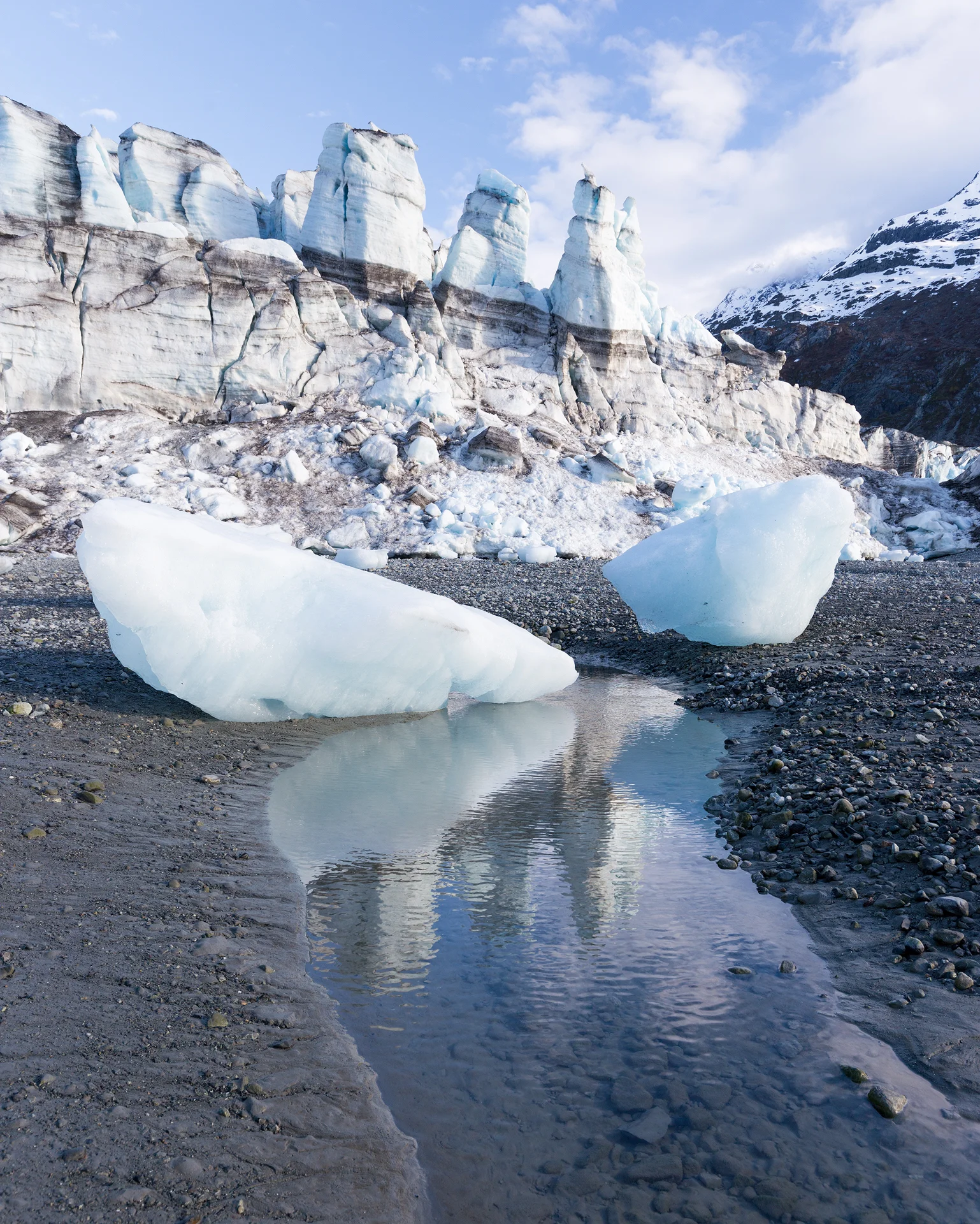
Viewing Lamplugh at low tide
From our camp the beached ice chunks looked small, like cooler-sized balls of ice but as we approached them we saw that they were actually massive, 10-foot-tall chunks of ice. We made sure to stay close to the shoreline and gave Lamplugh plenty of space, knowing that if a large piece of the glacier calved off it would shoot ice at us with the force of an explosion.
We made our way to the furthest shore, into a cove that was hidden from view while we were at camp but, judging by the constant noises we heard coming from it, seemed to be home to the most active portion of the glacier.
Lamplugh Glacier reflections
The wall of ice was breathtaking. I quickly began snapping photos of it when suddenly a huge piece of ice sheared off the face of the glacier and fell into the water with a thunderous roar. The whole situation was so unexpected and happened so quickly I could hardly believe my eyes.
It was also a visible reminder of just how powerful these glaciers are and Alex and I quickly made our way back to camp, not wanting to witness an even larger calving event.

Lamplugh Glacier calving
Our fourth day was the second longest paddle but ended up being the most harrowing day. The plan was to paddle from Lamplugh, all the way to the head of the Tarr Inlet to camp within view of the Margerie and Grand Pacific glaciers. As we were slowly making our way up the inlet the weather seemed to be favorable — blue skies peeked through the clouds, there was little wind, and the water was calm. As the day wore on the sky to the northeast began to look more ominous. Dark clouds consumed the peaks of mountains and a wall of rain looked to be heading in our direction. In what felt like a few minutes our beautiful blue bird day transformed into a small gale. The wind buffeted us and threw water from the crests of waves, subjecting us to whitecaps that didn’t come from one singular direction. In an instant our efforts went from enjoying the scenery to staying in our boats. We jabbed at the waves with our paddles, trying to weave in and out of the whitecaps. The ordeal lasted all of ten minutes but by the end I was so drained I could do nothing more than nod when Alex asked, “Are you okay?”
Thoroughly worked from the storm I wanted nothing more than to make it to camp. Finally, after a nine mile paddle we found ourselves on the rocky shores of a beach. We once again searched for bear signs but found only a couple of belly holes and there was no telling how old those were so we quickly set up camp.


That evening we had planned to paddle to Margerie Glacier, in hopes of seeing another (small) calving event, however, as we made our way to the glacier we encountered a sea of ice. All of the recent calving left chunks of ice ranging in size from golf balls to cars floating together in one solid mass, blocking us from continuing onward. We floated at that spot, hoping to catch a glimpse of the glacier calving but unfortunately saw nothing. We returned to the tent, feeling a little defeated and a lot tired. Despite the fact it was only 8pm we decided to call it a night. The following morning we had to embark on our longest paddle yet: 15 miles from Tarr Inlet back to Reid Glacier. We wanted to leave with the outgoing high tide, which meant our time of departure was about 4am. We set an alarm for 3:30am and I promptly fell into a deep sleep.

The next morning our alarms rang altogether too early. I groaned and tried to retreat further into the warm embrace of my sleeping bag. Then Alex unzipped the tent and we were greeted with pastel skies over the glaciers. I couldn’t believe how beautiful the scene was. We hadn’t seen a sunrise or sunset in days but this view made me realize how much we may have been missing.

Sunrise from our camp in the Tarr Inlet
As we broke down camp the sky continued to brighten. The clouds turned pinker and the perfectly still waters of the bay reflected the cotton candy clouds. It was tough to keep on pace and we ended up leaving 45 minutes late, but I think it was well worth it.
The paddle back to Lamplugh from Tarr Inlet took half the time it did the previous day. The water was eerily calm, our kayaks slicing through the water like a hot knife cuts through butter. The air was still and, except for the intermittent call of a bird and our metronomic paddle strokes, it was completely silent.

Paddling down the Tarr Inlet at ~6am
We spent the morning paddling to Lamplugh where we took a four hour break to eat a proper breakfast and relax before continuing on to Reid Inlet.
Once back at Reid Inlet we set up camp in the same area we had the first night, but the clear skies made it seem as if we were at an entirely new location. Mountains that were completely engulfed in clouds on our first night demanded our attention with their lofty peaks on this second visit.
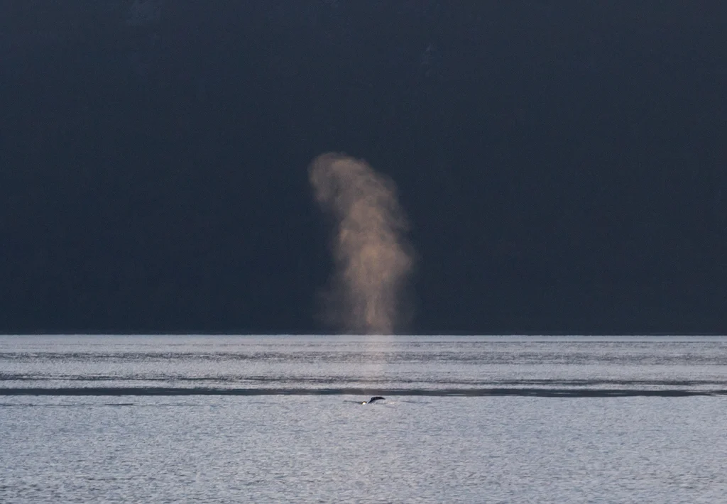
That night Alex woke me at midnight by whispering, “There’s a whale outside our tent.” I sat up, alert and listening. A few moments later I heard the distinct sound of a humpback whale’s exhalation. It must have been feasting in the waters outside our camp because we heard it for the next couple of hours, splashing and breathing, disappearing back into the depths of the bay and then surfacing again a few minutes later.
By the time the sun rose we thought the whale had moved on to another feeding ground but as we were breaking down camp we heard it surface again, and then, for the first time since hearing it hours prior, we saw it. Its breath hung in the air in a mist, glowing in the early morning light. Its smooth back broke the surface and then as it prepared for another dive, its tail flicked out of the water and slowly faded into the inky sea. I couldn’t have asked for a better last morning of the trip. It was as if everything had culminated into this final show and I was overcome with a feeling of gratitude and appreciation for this park. It’s a place that has so much to offer - endless beauty, bountiful wildlife, and solitude. I could never imagine up a place to be as spectacular as Glacier Bay.

An important note about Glacier Bay: The Tlingit people called this area home for millennia. They knew it as a lush valley with a bountiful salmon supply that sustained their families for generations. However, as the glaciers encroached on their land they were forced to search out a new place to live. They moved to Huna. After the Little Ice Age passed the glaciers quickly retreated, leaving new and “unoccupied” land in their place. The United States government claimed it, despite the fact that the Tlingit knew it as their home and had planned to return. This has caused some tense relations between the Tlingit people and the US government. To me it’s important to know the history of the places I recreate on, to know that while this is currently named Glacier Bay National Park, it is also an entire people’s homeland and those people and their land deserve our utmost respect.