
Middle Sister Up and Over

DATE HIKED: 4/20/25
TOTAL MILEAGE: 15.5 MILES
TOTAL ELEVATION GAIN: 5,500’
This past weekend Alex and I made a bit of a last minute decision to drive all the way to Sisters, OR to climb and ski Middle Sister. We had this tour slated as a potential Memorial Day trip, but when all of Washington looked gloomy over the weekend, I searched for sunnier locations. There was always the option of staying home and having a chill weekend, especially after being in Alaska the previous two weekends, but spring ski season is short and if we could get out there, I wanted to get out there. Central Oregon was forecasted to be dryer and sunnier than Washington, so on Saturday at 10AM, Alex and I made the call to pack the car, drive to Oregon, and attempt Middle Sister the following day.
We also needed to decide which route we wanted to do. I had hopes of skiing the south face, reading some trip reports that waxed poetic about how fun that 2,000’-3,000’ ski line is, but it’s a bit of a circuitous journey to get there. Many people complete that route in two days, opting to spend a night at Camp Lake, but that wasn’t an option for us. The Hayden Glacier is the “climber’s route” and is more direct (about two miles less of meandering in each direction), but it doesn’t offer as much fall line skiing. A shorter approach was very appealing to us so we thought, what if we combine the two routes and ascend via the Hayden and descend via the south face. However, this option meant that we could not scout our descent on the way up, and we wouldn’t be able to assess the snow quality on the face until we were on top of it. After some deliberating, we decided that a shorter route and the prospect of getting to fully explore the mountain sold us on the “up and over”, as I started calling it.
Just before noon on Saturday we piled all our gear and sleeping platform into the car and set Pole Creek Trailhead as our destination. Google maps told us it would take exactly six hours to get there. We put on some tunes and hit the road.
The drive down went faster than I expected. We left a dreary Seattle and slowly the skies cleared as we made our way south.

We arrived to the trailhead at 7PM and I was surprised to see only one other car there. It was a solo climber who had made his own last minute decision to drive from Portland and climb Middle Sister the following day. He was camping though, so he headed out shortly after we arrived. Alex and I got to work setting up our sleeping platform and then crawled into the car, watched an episode of Black Mirror, and set our alarms for 4AM before trying to get some sleep.

At 4AM our alarms sounded. I groggily looked outside and thought I saw headlights approaching, Ooh fellow climbers, I thought before realizing I was looking at the moon rising over the horizon. We were still alone.
We geared up and hit the trail at 4:45AM. We knew there would be snow on the trail from the satellite imagery, but didn’t know quite when we would hit continuous snow. I’ve been burned by not bringing trail runners in the past so we opted to start the hike in trail runners and carry our skis and boots on our backs. We hadn’t needed to pack the trail runners though, because just 0.4 miles from the trail we hit continuous snow, evidenced by multiple ski tracks ending in the same spot. We completed our first transition of the day, stashed our shoes in some bushes, and continued on.
The low snow line made travel so easy. When reading about this route or watching videos of it, nearly everyone lamented the numerous blowdowns, some saying they slowed travel to a 1 mph crawl. Thankfully for us, those blowdowns were still buried under the snow so we cruised right over them, none the wiser. The snow line also meant we could make our own way and cut down the mileage.


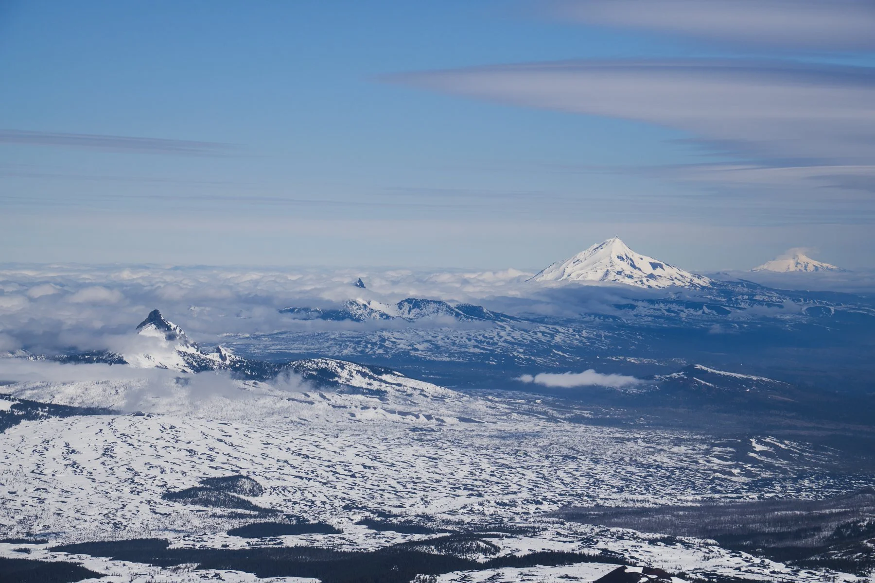
After an hour of hiking by headlamp, the sky started to lighten and illuminate our surroundings. To the south we could see Broken Top and South Sister and to west, directly in front of us was the jagged, imposing face of North Sister. North Sister is the oldest of the trio and time has worn her down, as time will do to anyone or anything. Her eroded ridges and rocky summit make her the hardest of the sisters to climb and we could tell that just by looking at her.
We made it to the base of the Hayden Glacier at 7AM, after two hours of moving. We ended up needing to traverse a couple ridges and the final descent to the glacier’s base was the longest and steepest so we transitioned to skiing for a brief moment. Just as we were descending, I saw the climber from the trailhead ahead of us on the glacier. He was still the only person we had seen all morning. We transitioned from skiing back skinning and started making our way up the Hayden.


The Hayden was fully filled in and was a perfectly gradual slope for efficient and continuous skinning. It even had a series of ramps that wound their way up to the col. The snow was a tad firm so I put ski crampons on, but Alex made his way just fine without them. I always feel like I need a little extra security with all my sharps!

The views from the Hayden were distractingly beautiful. Broken Top, Mt. Bachelor, and stunning views of all three Sisters made the ascent up the glacier a joy.


But not so joyously, we also encountered our first wind gusts of the trip during this section. We knew wind and clouds were forecasted, and they were supposed to grow increasingly stronger throughout the day (one of the reasons for our early departure). By 2PM, the winds at the summit were forecasted to gust 30mph while mid-mountain was supposed to gust 25 mph. Currently, the forecasts claimed the winds should be gusting only 15 mph.

Alex makes his way toward the col
At 9:15AM, we made it to the col and were immediately blasted by the wind. Oof, is this what it’s going to be like until we get to the summit?! We took a break at the col as we piled on all our layers and transitioned to booting with crampons. We hoisted our skis onto our backs and began the last ~800’ push to the top. Thankfully, just off the ridge the wind died down, whew! The snow on this section was wildly variable. Some pockets were soft and perfect for kicking steps, some pockets were gross icy sastrugi, but most of it was hard pack that made for a great French-stepping surface.

Booting up the final ~800’
An hour after setting off from the col, we arrived to the summit. I didn’t like those stats, I felt so slow, the elevation was starting to affect me, but we still made it to the summit faster than we thought we would. Just under six hours from the car. We looked around, surrounding us in all directions were volcanos! The solo climber arrived just after us, we marveled at the views and the fact that we were still the only three people on the mountain.


Alex and I sat on our backpacks and ate lunch while we waited for the corn to continue to ripen in the sun. We weren’t sure how much longer we’d have to wait, it was just after 11AM and we were hoping to ski a south facing slope. I figured sometime around 11:30 to noon would be sufficient, so we waited half an hour. In that short span of time clouds began to form around us, the forecasted front was heading our way. It was a conundrum. We wanted to wait a bit longer for the corn, but we also wanted to avoid the incoming weather, and there was a six hour drive back to Seattle that was also in the back of our minds.

Looking down the steep icy slope just off the summit ridge
Just after 11:30AM we geared up and skied off the summit toward the south slope, onto new terrain. Alex stopped at the edge of a ridge and said “where do we go?” Oh boy, I immediately started to regret descending a slope we hadn’t ascended. I pulled up next to him to look at what he was assessing. It was a steep slope covered with chunky frozen snow. That didn’t seem right. We peered over another ridge and looked down the southeast ridge. That looked even worse, rocks and frozen debris were everywhere, so we turned back to the chunky ice slope. It was steep, a sustained 35-45 degree angle for quite a ways, not a time or place to fall.
Alex made the first few cautious turns down the slope and it sounded rough. His skis scraped against the ice and shrieked with protest. He came to a stop just below the worst of it and radioed up to me that it was icy, but doable. I looked down, side slipped a few feet and then radioed back, “I’m going to just side slip this.” At that moment I had no shame in forgoing turns (though now writing this, I have a little shame), I slid my way down to him and came to a stop. He took the next pitch and radioed back again that it was rough, “don’t gain too much speed, it’s going to buck you”. I cautiously linked turns down the icy slope as my skis sputtered and skidded beneath me. This was not the skiing I had envisioned when we set out on this adventure.

One more pitch of riding an icy bucking bronco and then Alex took a few turns, looked back at me, smiled and said “I think we found some corn!” I took a few turns of my own and it appeared we had. The frozen slope had given away to nearly-corn. We had also transitioned to a more southeasterly face vs. southwesterly face, and that little extra time in the sun was all that was needed to create the conditions for great snow. The worst of the skiing was over, now we had fun skiing ahead of us. We really milked the next couple thousand feet of skiing long solo runs. Those turns had made it all worth it!

Next, all we had to do was get ourselves back to the trailhead. Again, the up and over nature of the route was playing against us. The terrain was all new to us, but we knew the general direction we needed to head and we had a great time finding our way there, down valleys and rollovers, and through the trees. It was type one fun.
However, while it felt like we were going the right direction, every time I pulled out the topo map on my phone I could see the fun fall line skiing was luring us too far to the right, when the trailhead (and our stashed shoes) were far to the left. “Keep veering left!” I told Alex. We’d stay on course for a few turns before somehow getting drawn to the right again. Eventually, we accepted that we needed to transition back to skinning to get on the right track. So we went up one ridge and then transitioned back to skiing (still trying to stay left). I checked my topo map and was frustrated to see we were too far right again! And so this went for two more ridges. Skin up to the left, ski down to the right, skin up to the left, ski down to the right.
Finally, we transitioned to skiing for the last time and were on our way toward our shoes. We stopped and I checked the pin I had saved for our stashed shoes, it said were were right on top of them. We looked around and sure enough, there they were, hiding safely under the bushes.
*****
Middle Sister was such a fun adventure. The “up and over” aspect, while challenging, added to the fun. Also, having virtually no one else out there added to the adventure. Alex and I were truly on our own route-finding and navigating, which is pretty rare these days with how busy the backcountry is and how many tracks there are to follow out there. It felt like a special experience and I’m so grateful I got to share it with Alex. Spending 10.5 hours climbing and skiing a mountain was far more fun than anything else we would have done over the weekend if we stayed home!
