
The Season Finale: Mt. Shasta via the Hotlum/Wintun Route
DATE HIKED: 6/7/25
TOTAL MILEAGE: 12 MILES
TOTAL ELEVATION GAIN: 7,200’
For the finale of our spring ski season, Alex and I had hoped to do something big, something that would be the culmination of six months’ worth of long days in the mountains and training, something that we couldn’t have done in January, before we logged all of the miles and vert on skis. Initially, we had our mind set on Rainier via the Emmons, but early June reports on the state of the upper Emmons steered us away. It seemed route-finding around crevasses and over snow bridges was extra tricky this year. But then we thought, what about a different 14,000’ Cascade volcano? What about Mt. Shasta? The ten hour drive intimidated us, as did the 7,200’ ascent and the 14,180’ high point, but the forecast for the weekend of June 6-8 looked ideal and recent trip reports were promising enough that we decided to make the long haul to California.
While the majority of climbers who summit Shasta flock to the tried and true Avalanche Gulch route on the south side of the mountain, a different route popped up in my research: the Hotlum/Wintun route that starts from the Brewer Creek trailhead. The Mount Shasta Avalanche org calls it “one of the most sought after ski/board descents on Mt. Shasta, as well as an excellent climbing endeavor”, and that was all it took to pique my interest. I did more research on the route and learned that it avoids not only crowds and glacier travel (no ropes needed!), it also avoids the dangerous rockfall that plagues the southern route. And if all of that wasn’t enticing enough, once you click into your skis at the top, you can ski over 7,000’ of mostly fall line skiing all the way to the road, no shenanigans like ski carries, side stepping, or skinning. I was sold.
On Friday, 6/6, Alex and I left a sleepy Seattle at 5:30AM with the Mt. Shasta ranger station set as our destination. Google maps told us we would spend the next 505 miles on I-5, making our way through Washington, Oregon, and into California. Every time I told someone of our hare-brained idea to drive to California in one day, their eyes shot up and their mouths dropped open. I started to second guess if it was a bad idea, but the drive ended up being easier than I expected. By 2PM, we made it to the town of Mt. Shasta where we picked up our ridiculously expensive climbing permits ($25 per person!), and loaded up on calories at the original Black Bear diner.

The heat in the city was oppressive, the temperature climbed into the 90s, and both Alex and I were cooking. We didn’t linger long at the lower elevations. Once we wrapped up our breakfast-for-dinners at the diner, we made the hour drive to the trailhead. The road was blocked by a patch of snow 1.5 miles from the trailhead (1.5 miles closer than it had been a week earlier), so we pulled off to the side and began setting up our sleeping platform and getting our gear situated. Given the high heat forecasted for the following day, and the very real possibility of a weak overnight refreeze, we decided on an early departure time, like middle of the night early. At 1AM.
We crawled into the car at 7PM to try to get to sleep. I’m not sure if it was the long drive that wiped me out, but I was able to fall asleep almost immediately, and all too soon our alarms were sounding at 12:30AM. Reluctantly, we got moving.

Just after 1AM, we officially began the climb with our skis on our backs and our boots on our feet. Recent beta suggested we would not need to walk long before hitting snow, so we left the trail runners in the car.
We followed the road for 1.5 miles until we made it to the Brewer Creek trailhead, but we could have slashed that distance had we taken a shortcut up through the forest on continuous snow. Unfortunately, we didn’t know the snow was continuous until we were on our way back to the car, so in the morning we added unnecessary distance and time to the trip.
The road was patchy with snow so we kept our skis on our back until the trailhead. We started up the true trail on patchy snow once again. Unbeknownst to us, just to hiker’s left was another stretch of continuous snow, but once again, we couldn’t see it in the dark so we spent even more time carrying our skis than necessary.
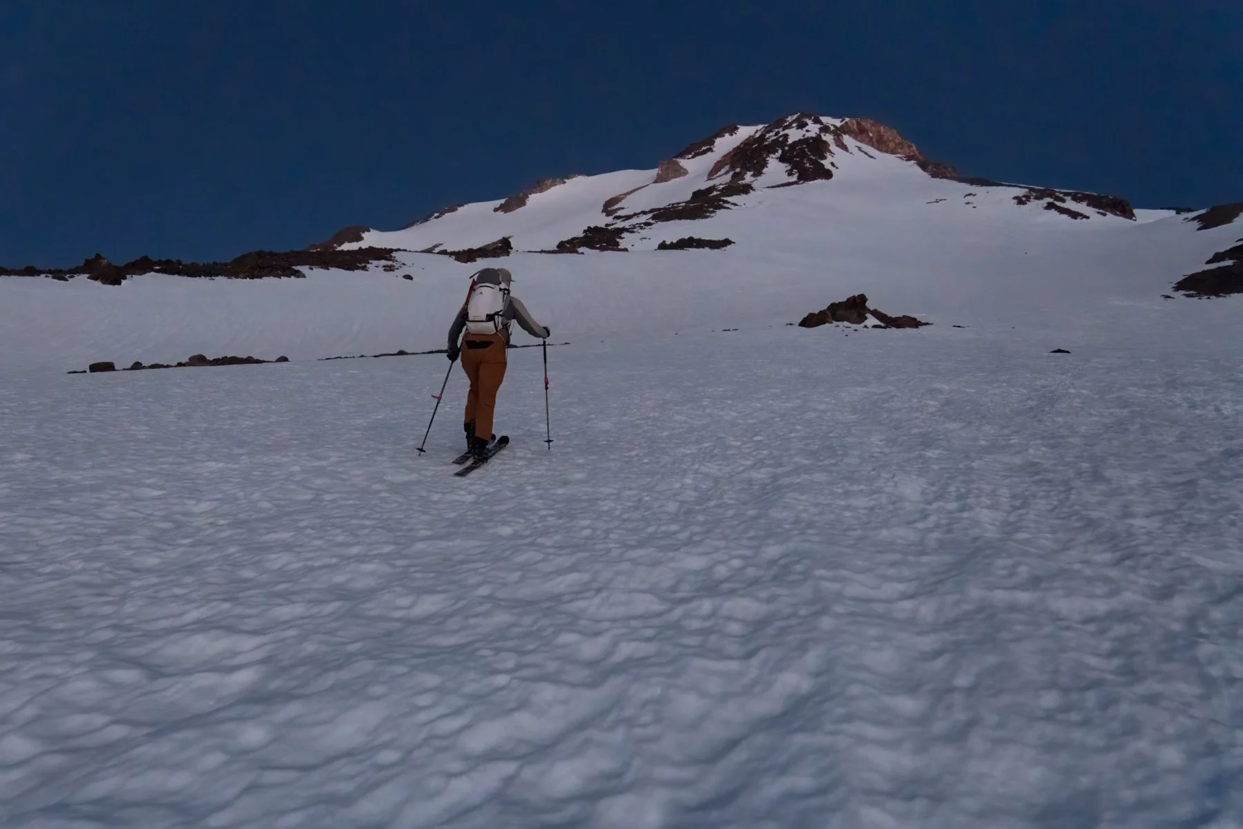
Finally, certain we had found continuous snow, we put our skis on and it was smooth skinning up through the forest to tree line. As we broke out of the woods, we could see headlamps on the mountain above us—a group camped on the rocks at 10k—they still looked so far above us, and yet thousands of feet higher above them was the summit of Mt. Shasta. We had barely gained 1,000’ in an hour and a half. The sight of how much we still had to climb was demoralizing. I was glad we left early because we were going slower than I expected.

We continued to make our way endlessly up by the halos of our headlamps. It was tough to ascend such a large snowy slope in the dark. I had a tough time gauging the slope angle when I could see so little by the light of my headlamp, so I resorted to taking out my phone periodically to check our location on Gaia and double checking we weren’t mistakenly making our way toward too steep of slopes.
At 10k we took our first packs-off break. A faint glow of crimson painted the horizon. After four hours of moving, we finally were graced by the light of the sun. With the sun came a newfound energy. Finally, we could see the world around us. We could see the rest of the route plain as daybreak above us. We had gained 3,000’ and the summit looked more within reach.


From 10k, the route ascended a large snowfield to 12.8k, where it traversed toward Ship Rock, and then straight up a chute to the summit. From below, this snowfield looked manageable and benign, but once we started climbing I realized how massive it was. We gained nearly 3,000’ on that snowfield. We made huge sweeping switchbacks up the face, back and forth and back and forth, and seemed to make only incremental progress. The sun had since fully risen and still it seemed we had only made it to the middle of the snowfield.


At 12.6k, I decided that the extra distance of traversing the entire snowfield for each switchback had started to result in diminishing returns, so I put my skis on my pack and began booting. Immediately, I regretted the choice. The extra weight of my skis felt outsized, usually booting feels a little harder for me than skinning, but at this elevation it required much more energy and effort. But, my decision was made, and in another 200’ I would have needed to switch to booting anyway. Alex joined me in booting, and also regretted it.

We completed the traverse toward Ship Rock and found ourselves looking up at one of the steepest booters I’ve ever seen. From about 13k to the summit, it was just one steep bootpack straight up the slope. We put our helmets on and took our ice axes out and began the long slog.


I felt okay the first few hundred feet, the climb was difficult, but manageable, but at about 13.5k I ran into a brick wall. Every step was a battle, my heart rate spiked, my head pounded, everything was hard. This was the highest we had been since we climbed Mt. Whitney in 2017 and I felt it!
We took another packs-off break at 13.7k. The summit was just above us, within reach, but still it felt far away. After five minutes of rest we set off on the final push. I trudged and trudged and thought that we must have covered a good distance since our break, but when I turned around, the rocks we had rested on were still comically close. We had barely made any progress at all. If I had the energy, I would have laughed. Alex said “just take 50 steps”. So I took 50 steps and then I took a break for 20 counts. I looked down at my watch, we had ascended another 40’. Every step was nearly a foot. That was heartening, a few more rounds of this and we’d be at the top! I took another 50 steps and a 20 count break, then another, and another. The summit grew tantalizingly closer.
There is a point in every climb when I realize, oh we’re actually going to do this! That moment did not come for me until we were at 14k, less than 200’ below the summit. Only with the summit a few minutes away, did I know we would do it.


Popping onto the summit was a bit of a shock. We went from the quiet side of the mountain, having encountered only a handful of other groups all day, and were thrust into a large crowd. At least 20 climbers were milling about on the summit, nearly all came up the Avy Gulch route.

We waited in line to take our summit photo and sign the summit register, and then headed back to the quiet side and took a long break. Despite my worry about our pace at the start of the day, we made it to the top in 8.5 hours, just after 9:30AM and ahead of schedule. The snow at the top of the chute wasn’t even ready to ski yet, so we waited for the sun to work its magic a little longer before skiing.

At 10:30AM, we decided we had waited long enough and dropped in. The top few turns were still a little crunchy, but the snow quickly turned smooth and buttery. For the next ~2,000’ Alex and I leap-frogged each other. The skiing was so fun I wanted to just rip down the mountain, but I got winded much faster than usual. This was officially the highest we had ever skied and the altitude was affecting me. I took more breaks than I’d like to admit as we made our way down, but in between those breaks I reveled in the ski.


We skied down to about 11,800’ and then traversed back toward the snowfield. From the top we had spied a narrow but continuous snow finger spanning the Hotlum/Wintun ridge and we beelined for it, happy to avoid taking our skis off and walking on rocks.
From there, we were on the massive snowfield it had taken us so long to ascend just a few hours prior. The snow had grown wet and grabby, and the turns were tough for already-tired legs, but we kept pushing and before we knew it we were back at tree line.
We were able to zigzag our way through the trees on continuous snow all the way to the trailhead. From that vantage point, it appeared there was also continuous snow through the forest and sure enough, we found a well-tracked luge that quickly led us to the road below, just a 5 minute walk from our car. This shortcut took so much time and distance off the road walk.
While it took us 8.5 hours to ascend, it took us only 1.5 hours to descend! Alex and I clicked out of our skis and carried them the short distance to the car. It wasn’t even noon yet. We were absolutely giddy, high on having set out to do something big and then accomplishing it. In fact, over a week later I’m still giddy. The 2025 ski season is going to be tough to beat!
*****
